There are many efforts for Earth observation around the world. Each county has been engaged in different kind of observations including not only Earth observation satellites, but also ground-based measuring instruments, aircraft, and ships, resulting in a wide variety of data. For climate change and disaster risk reduction, it is more urgent than ever to combine these various types of observation data, strengthen the observation system for changes in the Earth’s environment in order to protect human life and property.
JAXA supports the Government of Japan to participate in the Group on Earth Observations (GEO) that is the only international framework for Earth observation. Through GEO, JAXA contributes to the UN and governments in making policy decisions on climate change and disaster risk reduction by sharing data which is scientific evidence of global forest, agricultural and greenhouse gas observations by satellites. In addition, GEO is leading initiatives to support the achievement of the Sustainable Development Goals (SDGs) through Earth observation. Furthermore, GEO is promoting the free and open data of Earth observation data, in accordance with GEO’s data sharing principles.
By participating in such international framework, JAXA is able to actively collaborate with relevant organizations and international organizations in each country, and aims to contribute to address global social issues more effectively than efforts by only JAXA’s Earth observation satellites.
What is GEO?
In 1994, Japan proposed to expand the international cooperation activities for the Earth observation satellite program conducted by the Committee on Earth Observation Satellites (CEOS)[1] to other observation activities than space-based observations, and establish Global Earth Observing System through cooperation among countries. As the Integrated Global Observing Strategy (IGOS) was formulated by CEOS in response to Japan’s proposal, awareness of global environmental issues increased worldwide, and the importance of global Earth observation was recognized at the G8 Evian Summit held in 2003. And after three Earth Observation Summits, GEO was established in 2005.
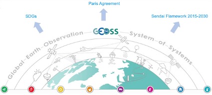
GEO is an intergovernmental organization that promotes the establishment of the Global Earth Observation System of Systems (GEOSS), that consists of multiple comprehensive and sustainable systems that cover the entire globe and integrate satellite, ground, and ocean observation and information systems. As of July 2021, 113 countries and more than 134 organizations including UN organizations, research institutes, and private sectors are participating. The goal is to develop an Earth observation system consisting of multiple comprehensive and sustainable Earth observation systems in each country, so that decisions and actions for the benefit of humanity are based on coordinated, comprehensive, and sustainable Earth observations and information.
Since 2016, based on the GEO Strategic Plan 2016-2025, each country has been sharing data obtained from satellite, ocean, and ground observations, as well as forecast results using such data, to promote GEOSS that contributes to policy making in cooperation with other countries in the eight social benefit areas of 1) Biodiversity and Ecosystem, 2) Disasters, 3) Energy and Mineral Resources, 4) Food Security and Agriculture, 5) Infrastructure and Transportation, 6) Public Health, 7) Urban Development, and 8) Water Resources, as well as climate change across these areas.
[1] CEOS was established in 1994


